Systems analysis in community work: Little Dip Conservation Park
Community challenges are always multi-dimensional. Although we would like them to be simple in structure and process, so that we can see and apply simple solutions to them—we all like a silver bullet—that is rarely open. More often there are multiple levels and many connections to consider, even in understanding what the parts are that make up the challenge, and where the boundaries of the challenge lie.
Systems thinking is a useful way to explore these dimensions of community challenges. It is a way to identify the different parts of a problem and to explore their interconnections. Even further, it’s possible to explore how the system behaves over time, as a whole, and what differences a range of interventions might have. These are called simulations.
It used to be the case that the analysis of systems dynamics and simulating possible trajectories was an arcane and expensive exercise which required considerable programming expertise. That is no longer the case. There are now platforms which are accessible by anyone, and are relatively simple to run.
A crucial advantage of systems analysis work on these platform is that they are primarily visual. It’s now possible to display them on a screen and work collaboratively to develop and test them. This makes the approach ideal for Community-Based Research, working together. So it’s an approach which is becoming more and more central to our work.
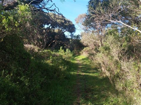
As an example, here is an initial analysis of the fire management system in the town where we are based, Robe, South Australia. Robe sits next to Little Dip Conservation Park. Most parts of Australia have experienced increasing frequency and severity of bush fires (in other countries, wildfires), notably in the Black Summer of 2019-2020. Robe is a small country town for most of the year–around 1500 permanent population–but this balloons to over 20,000 over the summer, as a population tourist location.
Over time, as we know, climate change has increased bushfire risk. Responding to that challenge is complex. Many sub-systems are involved: the native vegetation dynamics of the Park itself; ongoing strategies for work on the ground to reduce the risk of bushfire and the impact of it, if it does occurs; the patterns of interaction with the Park by local people and by visitors ; planning for a bushfire event to minimise impact; and so on. There are multiple, overlapping jurisdictions. Understanding all these elements and their relationships, in the overall system, is critical to the development of coherent and effective strategies and interventions.
Systems analysis and mapping can help here. Here is a first pass of such mapping, using the Stella platform. It is a well-established and well-supported platform, a pioneer in the field. We at RCA are most grateful to isee systems for their 2022 donation of Stella software for our work (https://www.iseesystems.com/).
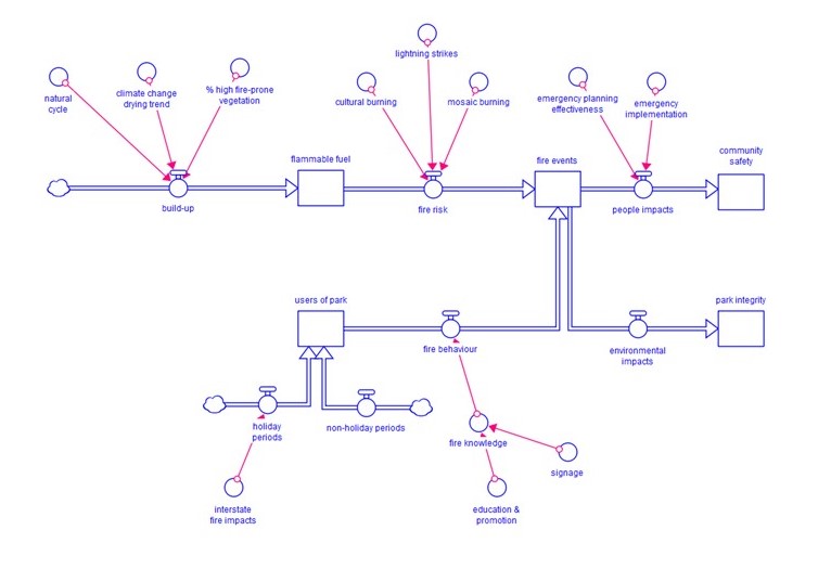
As you can see here, the two, interlinked outcomes we are seeking are ‘community safety’ and ‘park integrity’. We’ve conceptualised the system as consisting of two main streams, both contributing the conditions for potential fire events: the native vegetation and physical conditions of the Park itself; and the people who interact with it. Coming out of the potential fire events, and feeding into the final outcomes, are inputs from emergency responses and management.
We’ve also included potential preventative measures. One comes from First Nations knowledge and experience, over tens of thousands of years, called cultural burning. The other is from contemporary strategies along similar lines, such as mosaic burning.
As this stage this mapping is beginning to lay out the different elements of the total system. Clearly further development of the chart is indicated. The second stage is then to gather data on the different inputs. Some of that data is publicly available. Other elements will be collected from local and cultural knowledge stewards.
With that data entered into the model, it will then be possible to model different kinds of interventions by the different stakeholders–council, state, community, First Nations, and so on. We will be able to simulate them over time, looking to their impact on the two main outcomes, community safety and park integrity. This will give us all a much clearer idea of what initiatives to prioritise and resource.
This is an example of the power of systems analysis in meeting local community challenges. We want to help our communities use it across the range of challenges we all face in the Limestone Coast.
Leave a Reply